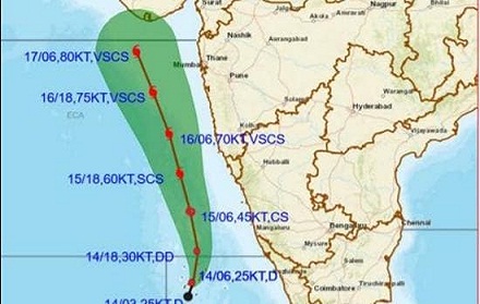
The depression in the Arabian Sea is likely to intensify into a “very severe cyclonic storm” on May 17 and cross the Gujarat coast a day later, the India Meteorological Department (IMD) said on Friday. The weather condition has intensified into a deep depression.
It is very likely to further intensify into cyclonic storm ‘Tauktae’ by Saturday morning.
It is very likely to intensify further into a severe cyclonic storm by Saturday night.
From May 16-19, it is very likely to intensify into a “very severe cyclonic storm” with a wind speed of 150-160 kilometres per hour gusting up to 175 kmph, Cyclone Warning Division of the IMD said.
It is likely to reach Gujarat coast by the morning of May 18.
The IMD has alerted the state along the western coast.
It said the Lakshadweep Islands will receive heavy to very heavy rainfall at isolated places on May 15 and heavy falls at isolated places on May 16.
Heavy to very heavy falls are expected at a few places on May 15 and heavy to very heavy falls at isolated places on May 16-17.
The ghat districts of Tamil Nadu are expected to witness light to moderate rainfall at many places with heavy to very heavy falls and extremely heavy falls at isolated places are very likely on May 14 and 15.
Karnataka (coastal and adjoining ghat districts) are likely to receive light to moderate rainfall at most places with heavy to very heavy falls at a few paces with extremely heavy falls at isolated places on May 15 and heavy falls at isolated places on May 16.
Konkan and Goa are expected to receive heavy to very heavy falls on May 15-16.
The coastal districts of Saurashtra in Gujarat are likely to receive rainfall from May 16 and heavy to very heavy falls are expected on May 17.
Heavy to very heavy falls at a few places, extremely heavy falls at isolated places over Saurashtra and Kutch are likely on May 18, the IMD said.
The name ‘Tauktae’ has been given by Myanmar which means ‘gecko’.
This is going to be the first cyclonic storm of this year along the Indian coast.

